About
Project Overview
The Virginia Creeper Trail stretches 34 miles from Abingdon to Whitetop, winding through forested slopes, creek valleys and some of Southwest Virginia’s most popular outdoor spaces. For many in the region, it’s part of daily life, a place to ride, walk, fish or spend time with family, and a driver of local tourism and business.
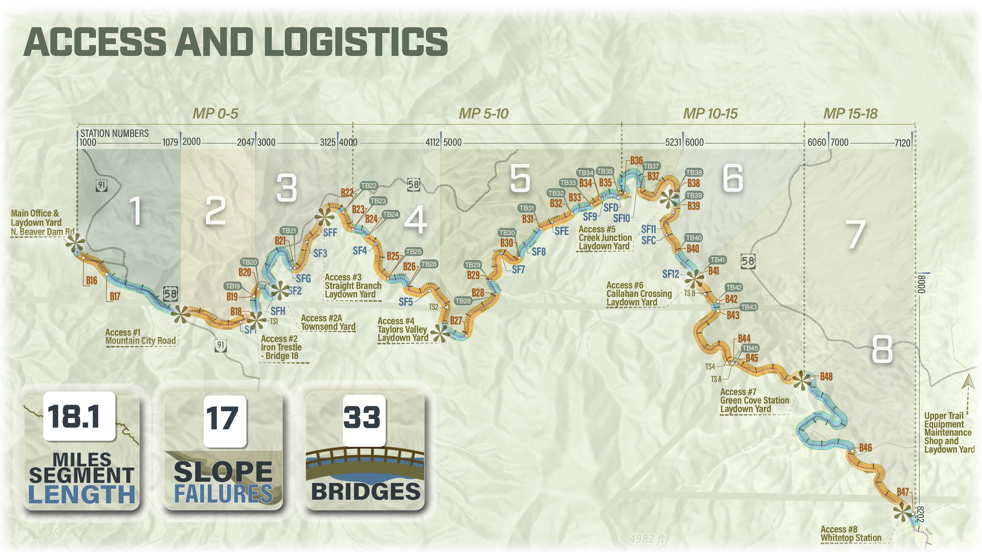
Reconstruction focuses on the 18-mile section managed by the U.S. Forest Service between Damascus and the North Carolina state line. Known for its trestle bridges, creek views and narrow mountain corridor, this upper portion is one of the trail’s most visited segments and a key link for riders traveling between Whitetop and Damascus.
Storm Impacts
Hurricane Helene caused the most severe damage along this section. Flooding displaced or destroyed 18 of the corridor’s 33 trestles, damaged the remaining structures and triggered 17 slope failures that destabilized large portions of the trail bed. Debris, rock and fallen timber remain throughout the corridor, limiting access and creating unsafe conditions.
Reconstruction Work
To restore safe public access, the U.S. Forest Service authorized a full reconstruction of this 18-mile segment. Kiewit Infrastructure South Co. is rebuilding damaged trestles, repairing remaining structures, stabilizing slopes, restoring the trail bed and drainage, and removing debris throughout the area.
Work also includes improvements at Straight Branch, Taylor’s Valley, Creek Junction, Whitetop Station and Green Cove Station, where parking areas, spur trails and restrooms were affected by the storm.
The corridor’s steep terrain and limited access points require careful planning. Crews are working in segments to safely move equipment, stabilize slopes and rebuild structures.
Bridge and Structure Status
Crews are continuing bridge demolition and restoration activities along the Virginia Creeper Trail as part of the overall reconstruction effort. Work is focused on addressing storm-damaged structures and stabilizing affected areas, with the goal of returning the trail to a sustainable condition with improved drainage, signage, safety parameters and engineered resiliency.
Bridge 16: Removal of approaches and decking
Bridges 17–35: Removal of existing bridge structures
Bridge 36: Steel span remains in place
Bridge 37: Removal of existing bridge structure
Bridge 38: Steel span remains in place
Bridge 39: Steel span remains in place
Bridge 40: Removal of existing bridge structure
Bridge 41: Removal of existing bridge structure
Bridge 45: Removal of existing bridge structure
Bridge 46: Removal of existing bridge structure
Bridge 47: Removal of existing bridge structure
Bridge 48: Removal of existing bridge structure
The civil scope of work includes restoring slope failures using engineered repairs that incorporate rock and geotextile fabric for stabilization, reinforcement and improved resiliency. These repairs are designed to reestablish safe and reliable access along the trail.
Minor grading will be performed to transition the existing trail to new bridge structures and reconstructed slope areas. The trail alignment will largely remain consistent with its pre-storm configuration.
Trail restoration activities along the entire corridor on National Forest Systems lands between Damascus and Whitetop will return the trail to an improved condition, with careful consideration of drainage and safety enhancements.
Taylor’s Valley Waterline Replacement
Due to Hurricane Helene in September 2024, much of the existing water pipeline was severely damaged. The waterline segment between Straight Branch and Taylor’s Valley is being replaced as part of a separate project adjacent to the Virginia Creeper Trail Reconstruction, with Washington County serving as the client.
Two construction methods will be used for installation: open-cut and horizontal directional drilling (HDD). Approximately 9,100 linear feet of pipeline will be installed using open-cut construction with 12-inch ductile iron pipe, while an additional 2,600 linear feet will be installed using HDD beneath the Creeper Trail.
The project includes four HDD crossings using DR-9 16-inch PE4710 HDPE pipe: HDD 1 at Bridge 23, HDD 2 at Bridge 24, HDD 3 at Bridge 25 and HDD 4 at Bridge 26. These sections will be connected through open-cut installation of 12-inch ductile iron pipe to complete the system.
Closure Notice
Please note: The U.S. Forest Service has closed the upper portion of the Virginia Creeper Trail from Trestle 16 in Damascus to near the North Carolina state line due to infrastructure damage and ongoing reconstruction. For public safety, access to this trail segment is prohibited during restoration.